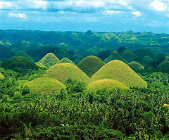
The Chocolate Hills form a rolling terrain of haycock hills – mounds of a generally conical and almost symmetrical shape. Estimated to be from 1,268 to about 1,776 individual mounds, these cone-shaped or dome-shaped hills are actually made of grass-covered limestone. The domes vary in sizes from 30 to 50 metres (98 to 160 ft) high with the largest being 120 metres (390 ft) in height. Bohol's "main attraction", these unique mound-shaped hills are scattered by the hundreds throughout the towns of Carmen, Batuan and Sagbayan in Bohol.
Banaue Rice Terraces
The Banaue Rice Terraces (Tagalog: Hagdan-hagdang Palayan ng Banawe) also called Payew, are 2000-year old terraces that were carved into the mountains of Ifugao in the Philippines by ancestors of the indigenous people. The Rice Terraces are commonly referred to by Filipinos as the "Eighth Wonder of the World". It is commonly thought that the terraces were built with minimal equipment, largely by hand. The terraces are located approximately 1500 meters (5000 ft) above sea level and cover 10,360 square kilometers (about 4000 square miles) of mountainside. They are fed by an ancient irrigation system from the rainforests above the terraces. It is said that if the steps are put end to end it would encircle half the globe.
Tubbataha Reef
Tubbataha Reef is located in the Sulu Sea, 98 nautical miles (181 km) southeast of Puerto Princesa City in the Palawan Province. The reef is made up of two coral atolls divided by an eight-kilometer (5 miles) wide channel. The South Atoll, the smaller of the two is five kilometers in length and three kilometers in width; while the North Atoll, the larger of the two is 16 kilometers (10 miles) long and five kilometers (3 miles) wide.(Knipp 22) Each reef has a single small islet that protrudes from the water. The atolls are separated by a deep channel 8 km (5 miles) wide.
Hundred Island, Pangasinan
The Hundred Islands National Park is the top tourist destination in Lingayen Gulf in the province of Pangasinan in northern Philippines.
This national park is one of the wonders of nature. With its 124 islands, it is a wonderful place for seeing nature, for boating, and for diving. It is also a top bird watching site.
Mayon Volcano, Albay
Mayon Volcano is the main landmark of Albay Province, Philippines. It is 10 kilometres (6 mi) from the Gulf of Albay, in the cities and municipalities of Legazpi City, Daraga, Camalig, Guinobatan, Ligao City, Tabaco City, Malilipot, and Santo Domingo (clockwise from Legazpi). It rises 2462 m (8,077 ft) above the gulf. Mayon Volcano is the Philippines' most active volcano and is considered to be the world's most perfectly formed volcano for its symmetrical cone. It is a basaltic-andesitic volcano. The upper slopes of the volcano are steep averaging 35-40 degrees and are capped by a small summit crater. Its sides are layers of lava and other volcanic material.
Taal Volcano
Taal Volcano Another one of the active volcanoes in the country, Taal Volcano is located between the towns of Talisay and San Nicolas in Batangas. It is considered an island inside Taal Lake, a body of water surrounding the volcano which is actually believed to be a former crater or mouth of a larger volcano. It is part of the Pacific Ring of Fire, making it very volatile. The volcano has become a very famous tourist spot; as a result, various establishments have been set up surrounding the lake. Due to its proximity to these establishments and human activities, the volcano is kept under close, tight watch for any signs of volcanic activities.
Mt Makiling
Mount Makiling -This one is a “dormant” or potentially-active volcano. Located in Laguna, it is one of the most popular destinations for hikers. There are actually roads going up this mountain but if you really want to see its beauty, you have to veer away from these roads and hike on foot. This mountain has a lot of hot springs inside, which are the source of the hot spring resorts surrounding the mountain. Part of Mount Makiling is located in the University of the Philippines, the premier university of the country and one of the designated caretakers of this lovely mountain. From afar, the mountain looks like a reclining lady, said to be Maria Makiling, the “guardian” of the mountain.
The Puerto Princesa Subterranean River National Park is located about 50 kilometres (31 mi) north of the city center of Puerto Princesa, Palawan, Philippines. The National Park is located in the Saint Paul Mountain Range on the northern coast of the island. It is bordered by St. Paul Bay to the north and the Babuyan River to the east. The park has a limestonekarst mountain landscape with an 8.2 kilometer navigable underground river. A distinguishing feature of the river is that it winds through a cave before flowing directly into the South China Sea. It includes major formations of stalactites and stalagmites, and several large chambers. The lower portion of the river is subject to tidal influences. Until the 2007 discovery of an underground river in Mexico's Yucatan Peninsula, the Puerto Princesa Subterranean River was reputed to be the world's longest underground river.
Maria Cristina Falls
Maria Cristina Falls is a waterfall of the Agus River on the island of Mindanao. It is sometimes called the "twin falls" as the flow is separated by a rock at the brink of the waterfall.It is a landmark of Iligan City, nicknamed the City of Majestic Waterfalls, because of the presence of more than 20 waterfalls in the city. It is located 9.3 kilometers away southwest of the city proper at the boundaries of Barangays Maria Cristina, Ditucalan, and Buru-un. Well-known for its natural beauty and grandeur, the 320 - feet (98 meters) high waterfall] is also the primary source of electric power for the city's industries, being harnessed by the Agus VI Hydroelectric Plant


No comments:
Post a Comment